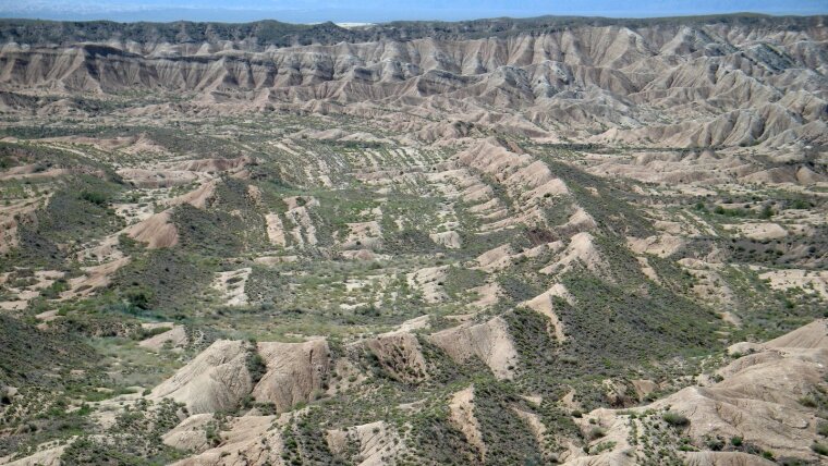
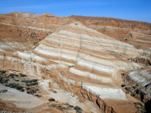
Folded Miocene lacustrine strata of the Ili basin, Kazakhstan
Our expertise
Our group has significant expertise in sedimentary processes and facies analysis of clastic and carbonate systems. Our sedimentological expertise ranges from detailed grain size analysis, sediment petrography and geochemistry to facies and basin analysis. Our expertise extends beyond detailed outcrop descriptions and mapping to the documentation and interpretation of cores and well logs.
Team
-
PD Dr. Thomas Voigt
Learn more de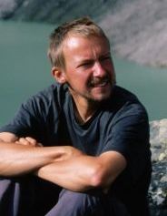
Thomas Voigt
Image: IGWPostdoc
Lehrstuhl Allgemeine und Historische GeologieE-Mail: thomas.voigt@uni-jena.de
Tel.: +49 3641 9-48628
Fax: +49 3641 9-48622Raum H108
Burgweg 11
07749 Jena -
Prof. Dr. Christoph Heubeck
Learn more de
Christoph Heubeck
Image: IGWE-Mail: christoph.heubeck@uni-jena.de
Tel.: +49 3641 9-48620
Fax: +49 3641 9-48622Raum H102
Burgweg 11
07749 Jena
Our projects since 2012
-
Bromacker
Learn more deIn order to understand the palaeoecosystem of the Tambach Basin in the Thuringian Forest, it is essential to understand the geological and palaeoclimatological contexts of the region in addition to studying the diverse fauna of the Early Permian in order to be able to draw conclusions about the landscape and ecological characteristics of the region and its climate.
To this end, we are carrying out four interrelated projects: (1) A systematic survey of the lithology and sedimentary facies from outcrops using the literature and new field surveys; (2) the knowledge gained from this will be incorporated into a 3-D cellular, low-resolution and patchy facies model of the geological subsurface (Skua); (3) this geological inventory identifies localities to drill two core holes to fill, extend and stabilise the facies model and to identify horizons that are correlatable with the Bromacker fossil deposit; (4) this allows the fossil-bearing Tambach Formation to be hooked into a new standard sequence of the basin. -
Petrographic-sedimentological characterisation and correlation of chalk deposits in the Saxon-Bohemian border area within the framework of the Interreg V A project "ResiBil"
ResiBil
2017-2020
ResiBil - Bilance vodních zdrojů ve východní části česko-saského pohraničí a hodnocení možnosti jejich dlouhodobého užívání
ResiBil - Water resource balancing and resilience assessment in the German-Czech border area
EU programme Objective 3/ Cíl 3: Programme for the promotion of cross-border cooperation Cooperation 2014-2020 between the Free State of Saxony and the Czech Republic
Lead - Partner VUV Research Institute for Water T. G. Masaryk, Prague
Project - Partner Saxon State Office for Environment, Agriculture and Geology (LfULG) Geology (LfULG), Department 44 Surface and Groundwater
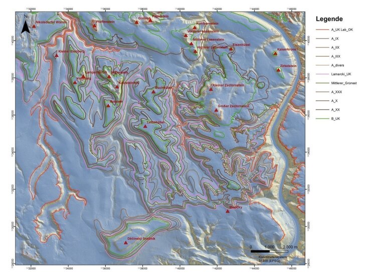
Geological map map of northern Bohemia and southeast Saxony between Decinski Sneznik and Bad Schandau
Image: Thomas Voigt -
Development of the Ili Basin and the uplift of the Tienshan Mountains
Miocene lake and mud flat sediments Koybin area
Image: Thomas Voigt2012-2019
Evolution of the Ili-Basin and the uplift of the Tienshan Mountains
The aim of the investigations is to decipher the evolution of the intramontane Ili Basin using a combination of different methods (facies analysis, basin-wide correlation of stratigraphic units, documentation of synsedimentary tectonics (progressive unconformities), provenance analysis and cooling ages). The data indicate that the uplift of the mountain ranges began much earlier than previously accepted. The work is supported by numerous bachelor's and master's dissertations. (Funding: Free third-party funding)
Supporting collaboration in the DFG project Voigt, S and Pross, J.
Neogene continental climate dynamics prior to the late Miocene uplift of the Northern Tien Shan (Kazakhstan)
-
Development of two 3D models of hydrogeological bodies in the Saxon-Bohemian border area within the framework of the Objective 3 project GRACE
SNCZ
Image: Thomas VoigtGRACE
2012-2015
Groundwater Absence in Cretaceous Sandstone Aquifers - Shared Groundwater Resources in the Czech-Saxon Border Region
EU Programme
Objective 3/ Cíl 3: Programme for the promotion of cross-border cooperation 2007-2013 between the Free State of Saxony and the Czech Republic
Lead - Partner VUV Research Institute for Water T. G. Masaryk, Prague
Project - Partner Saxon State Office for Environment, Agriculture and Geology (LfULG) Geology (LfULG), Department 44 Surface and Groundwater
-
Knowledge analysis of the red sandstone of Thuringia
Documentation on the state of knowledge in the red sandstone of Thuringia
2012-2015
Sovereign assistance service Creation of thickness and facies maps, Data sheets for the most important outcrops
Project - Partner Thuringian State Institute for Environment and Geology
-
Knowledge analysis of the shell limestone of Thuringia
Knowledge analysis of the shell limestone of Thuringia
2016-2017
Sovereign assistance Tasks: Creation of thickness and facies maps, data sheets for the most important outcrops, development of facies of facies models for the Lower, Middle and Upper Upper Muschelkalk
Project - Partner Thuringian State Institute for Environment and Geology
-
Documentation of the state of knowledge of the Ordovician in the Free State of Thuringia
Knowledge analysis of the Ordovician of Thuringia
2017-2018
Sovereign assistance service Creation of thickness and facies maps, correlation tables, data sheets for the most important outcrops outcrops, development of facies models for the different different groups of the Thuringian Ordovician
Project - Partner Thuringian State Institute for Environment and Geology
-
Provenance of Triassic sandstones in Romanesque monasteries in Thuringia
Determining the origin of Thuringian sandstones in Romanesque buildings
2016-2017
Co-operation agreement, joint project documentation of the Romanesque monasteries Roda, Thalbürgel, Lausnitz and Paulinzella stones used, characterisation and comparison via thin sections and colour spectrometry, evaluation of the DGM2 of Thuringia to search for age hollow moulds as evidence of medieval quarries
Project - Partner Institute for Stone Conservation
-
Mapping of subrosion phenomena in the southern Harz foreland in the subject area|field of Sangerhausen (3 contracts)
Mapping of subrosion phenomena in the southern Harz foreland in the subject area|field of Sangerhausen (3 contracts)
2016-2018
Evaluation of the DGM1 of Saxony-Anhalt in the south-eastern Harz foreland
Cooperation agreement, joint project old mining in the copper slate and the subrosion of the gypsum and salts of the Zechstein in southern Saxony-Anhalt. Anhalt have led to a distinctive morphology which is relevant for engineering geological geological questions. With the help of DGM 1 and and various derived geodata mapped and categorised.
Project partners State Office for Geology and Mining Saxony-Anhalt.
-
Mapping of the lithostratigraphic boundaries in chalk sediments on grid sheet 5050
Mapping of the lithostratigraphic boundaries in chalk sediments on Ordnance Survey sheet 5050
2017
Cooperation agreement, joint project Determination of the spatial position of the superficial boundaries between Labiatus Labiatus sandstone and sandstone a, Boundary horizon alpha3 (sandstone a to sandstone b), boundary horizon beta1 (sandstone b to sandstone c), boundary horizon gamm 3 (sandstone c3 to sandstone d), boundary horizon delta2 (sandstone d to sandstone e) between Leupoldishain, Waltersdorf, Gohrisch and Cunnersdorf. Creation of a stratigraphic and DGM-based model in the area Königstein area for the prediction of rockfalls and landslides through terrain mapping (with GPS and barometer) and evaluation of the DGM2 of Saxony
Project - Partner Saxon State Office for the Environment, Agriculture and Geology (LfULG), Department 44 Surface and groundwater
-
Thin section evaluation and interpretation for subsoil and raw material exploration (Ingenieurbüro Hallbauer & Ebert and Jena GEOS)
Thin section evaluation and interpretation for subsoil and raw material exploration (Ingenieurbüro Hallbauer & Ebert and Jena GEOS)
Mineral identification in thin sections, qualitative, quantitative, description of the microstructure and documentation of alteration phenomena
Service contract examples: Flood protection in the Aubach valley near Greiz, New bridge construction in Pößneck, Auerbach subsoil, Building ground St. Egidien, building ground Wünschendorf, Rodewisch building site, machine foundation Fraureuth, bridge replacement junction Neumühle, forestry educational institution|training centre Bad Reiboldsgrün
Project - Partner Hallbauer and Ebert foundation engineering office, Spiegelstraße 31, 08056, Zwickau