KI4KI - Artificial Intelligence for Climate-Resilient Infrastructure Monitoring
KI4KI—Artificial Intelligence for Climate-Resilient Infrastructure Monitoring—was funded between 2022 and 2025 as a collaborative project of the BMWK (Federal Ministry for Economic Affairs and Climate Action) between Friedrich Schiller University Jena and the Ruhrverband (Grant ID: 50EE2202A). We developed AI-based approaches for multi-temporal interferometric synthetic aperture radar (MT-InSAR) time series to monitor deformations on dams in Germany.
Contents
-
1. Background and Study Site
Persistent Scatterer Interferometry (PSI) is established as an extremely useful and powerful technique for infrastructure monitoring. The use of PSI enables the precise and regular monitoring of movements and deformations on large-scale infrastructure, particularly dams. In combination with the use of so-called electronic corner reflectors (ECRs), PSI technology offers an effective solution for increasing the visibility of infrastructure in the radar image and thus enabling its regular monitoring. The combined use of various satellite sensors, followed by the segmentation of dams into individual sections, enables localized and meaningful consolidation of deformation data. Through the use of artificial intelligence (AI), the drivers of these movements can be identified and predictions made regarding the future movement behavior of the structures. These advanced approaches open up new possibilities for effective monitoring, risk assessment and protective measures to strengthen the resilience of our infrastructure against environmental influences.
The research project was carried out in collaboration with the RuhrverbandExternal link, which, through its facilities, ensures the water supply for 4.6 million people in the Ruhr area. Of the eight dams in North Rhine-Westphalia operated by the Ruhrverband, six were selected for various research activities as part of the KI4KI project. To ensure that the selected dams were visible in the radar imagery, ECRs were installed on the walls and embankments of the Möhne, Sorpe, Verse, Bigge and Lister Dam. In addition, the Ennepe and Glör Dam were also investigated, though they were not equipped with ECRs. The plausibility of the satellite-based deformation analysis was verified on the basis of high-resolution in-situ measurements carried out by the Ruhrverband.
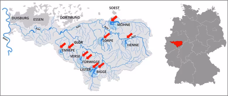
Study Area.
Image: Ruhrverband -
2. Project Organisation and Dissemination

KI4KI Workshop Jena
Image: Jonas ZiemerKI4KI was carried out as a joint project between the University of Jena (FSU) and the Ruhrverband. The project was managed by the university chair of Remote Sensing (FSU-EO) under the leadership of Prof. Dr Christiane Schmullius de. The Computer Vision Group (FSU-CVG)External link from the Faculty of Mathematics and Computer Science was also involved, contributing in particular to the development of methodologies. Thanks to close collaboration with the Ruhrverband as a project partner, the first research findings were published just halfway through the project’s total duration of just over 3.5 years (04/22–12/25). This was also made possible by the partners and research institutions associated with KI4KI.
The project results were presented at numerous meetings and conferences. This particularly fostered dialogue with dam operators and other research institutions. In addition, a total of three user workshops were held on the topic of "infrastructure monitoring using satellite remote sensing". In dedicated sessions, participants from the fields of research, industry and public authorities were able to discuss the latest developments in this field of research. The workshops took place in Jena and are set to continue as part of the RESTIM-Symposium (REmote Sensing for Transport Infrastructure Monitoring). Further information on the symposium will soon be available on the websites of the Federal Highway and Transport Research Institute (BASt)External link, the Federal Institute of Hydrology (BfG)External link and the German Centre for Rail Traffic Research (DZSF)External link.
-
3. Research Focus
- Feasibility analysis of various dams for a satellite-based monitoring strategy
- Combining sensors of various satellites for spatiotemporal densification of radar time series
- Deformation prediction on dams using data-driven approaches
- Development of a monitoring system for dam deformations based on electronic corner reflectors (ECR)
- Development of an application programming interface (API) for visualising the results for dam operators
-
4. Team
- Clémence Dubois (Dr.-Ing.)
- Jannik Jänichen
- Jonas Ziemer (Dr.)
-
5. Publications
Scientific articles:
- Satellite monitoring of movements in the Möhne DamExternal link
- Enhancing the Prediction of Dam Deformations: A Novel Data-Driven ApproachExternal link
- Assessing the Feasibility of Persistent Scatterer Data for Operational Dam Monitoring in Germany: A Case StudyExternal link
- Towards Operational Dam Monitoring with PS-InSAR and Electronic Corner ReflectorsExternal link
- Identifying Deformation Drivers in Dam Segments Using Combined X- and C-Band PS Time SeriesExternal link
- Evaluating the German Ground Motion Service for Operational Dam Monitoring: A Comparison of InSAR Data with In Situ MeasurementsExternal link
- A Novel Amplitude-based Approach for Reducing Sidelobes in Persistent Scatterer Interferometry Processing using Spatially Variant ApodisationExternal link
- An Integrated Monitoring Concept for Dam Infrastructure: Operational PSI Service and Application of Electronic Corner Reflectors (ECR)External link
Conference papers:
- KI4KI: New project for the regular monitoring of dams from spaceExternal link
- Monitoring of the Möhne Dam using satellite-based persistent scatterer interferometryExternal link
- Comparison of ground movements with in-situ measurements for monitoring deformations in dam structures in ThuringiaExternal link
- SNAP2StaMPS v2: Expanding Features and Supported Sensors in the Open-Source SNAP2StaMPS Processing SchemeExternal link
- Sensor fusion for detecting movement patterns of gravity dams in Germany using SAR interferometryExternal link
- Enhancing Dam Monitoring: Utilising the CR-Index for Electronic Corner Reflector (ECR) Site Selection and PSI AnalysisExternal link
- Data-Driven Prediction of Large Infrastructure Movements Through Persistent Scatterer Time Series ModellingExternal link
- Dam Monitoring Using Ground Motion Services – A Case Study of a Gravity Dam with the German Ground Motion ServiceExternal link
- Initial Assessment of Electronic Corner Reflectors for Dam Monitoring in GermanyExternal link
- Optimising Dam Monitoring: Validation and Optimisation of the CR-Index for PS-InSAR and Electronic Corner Reflector (ECR) IntegrationExternal link
Book chapters:
- AI in Geodesy and Geoinformatics: Artificial Intelligence in Remote Sensing for Climate-Resilient Infrastructure Monitoring
-
6. Theses and Dissertations
Bachelor's Theses (B.Sc.)
- Spieß, L. (2024). Development and implementation of an automated workflow for the integration of InSAR products into an online service
Master's Theses (M.Sc.)
- Stumpf, N. (2025). Dam Monitoring – Optimisation of Sidelobe Suppression in Radar Images during StaMPS Persistent Scatterer Interferometry Processing.
Doctoral Dissertations (Dr. rer. nat.)
- Ziemer, J. (2026). Advancing Dam Monitoring: Integrating MT-InSAR and In Situ Data for the Analysis and Prediction of Dam DeformationsExternal link
- Jänichen, J. (tbd): Operationalisation of Interferometric SAR Data for Dam Infrastructure Monitoring
Research Focus in Detail
-
1. Suitability Analysis for a Satellite-based Monitoring Strategy
In the first part of the project, the suitability of various types of dams (e.g., dam walls and embankment dams) for a satellite-based observation strategy was assessed. The methodology aimed to develop two indices to...:
- assess the general visibility of dams in radar imagery based on data availability, topography and land cover, and
- convert and interpret deformations in the sensor’s line of sight (LOS) into deformations in the radial direction relative to the crest of the structure.
For this purpose, freely available MT-InSAR datasets from the German Ground Motion Service (BBD)External link were used.

Ascending LOS sensitivity (%) to radial deformations in dependence on the radial orientation of the dam crest (°). The LOS sensitivity is expressed as a proportion of the true radial deformation (mm). Orthophoto: GDI-NRW (2024), EPSG: 25832.
Image: Jonas Ziemer -
2. Combining Sensors of Different Wavelengths for Spatiotemporal Densification of MT-InSAR Time Series

Segmentation of a dam into segments with different deformation characteristics. The PS points of the segments are shown in different colors and combined into a mean deformation profile over time.
Image: Jonas ZiemerIn the second step, data from two different radar sensors operating at different wavelengths – TerraSAR-X (X-band) and Sentinel-1 (C-band) – were combined to generate a spatially and temporally densified time series. To this end, a new tool called TSX2StaMPSExternal link was developed, which enables high-resolution TerraSAR-X data to be pre-processed using ESA’s open-source SNAP software. TSX2StaMPS is already integrated into snap2stampsExternal link as an updated version and was presented at ESA’s Fringe Conference in Leeds in 2023.
The dams were divided into different segments and their deformation behavior was analysed using the combined TSX/S1 time series. By combining data from both sensors, it became possible to observe how the mean deformation profiles differ depending on the location of the individual segments. Furthermore, the deformation drivers were identified using in-situ data.
-
3. Deformation Prediction using Data-driven Approaches
As dam operators are concerned not only with analyzing past deformations but, in particular, with predicting future movements at their dams, the FSU-EO and FSU-CVG groups aimed to investigate the prediction of dam deformations using data-driven approaches. The aim was to improve the predictive accuracy of present models. A wide variety of algorithms were employed, including time-series forecasting models, ensemble methods and deep learning approaches. By implementing the algorithms into existing workflows, the prediction accuracy was considerably improved for both PS data and in-situ measurements.

Left: Pendulum line (orange) and PS points (blue) at the Möhne Dam. The deformation prediction (in mm) for the year 2020 was determined through a comprehensive model search. Right: Turquoise dots represent the training data, while gray dots represent the test data recorded by the pendulum system (Ruhrverband, 2021). The colored lines show the predicted deformation from the best-performing model in each search space. Orthophoto: GDI-NRW (2024), EPSG: 25832.
Image: Jonas Ziemer -
4. Monitoring Dam Deformations based on Electronic Corner Reflectors (ECR)

Electronic corner reflector (ECR) with a solar panel for power. Installed here on the crest of the Bigge Dam.
Image: Jonas ZiemerUnfortunately, not all dams meet the necessary criteria for a satellite-based monitoring strategy. For example, unfavourable topographical conditions or vegetation-covered surfaces can affect the detection of PS points on dam structures. To enable these dams to be monitored nonetheless, six electronic corner reflectors (ECRs) were installed at five dams managed by the Ruhrverband as part of the project. Over an observation period of more than 2.5 years, the ECRs provided stable radar signals and enabled deformation time series with millimeter accuracy. The results were compared with in-situ measurements carried out by the Ruhrverband and confirm the general suitability of ECRs for dam monitoring.
-
5. Development of an Interface for Visualizing Results for Dam Operators
In order to translate the scientific findings of the research into operational practice, a web-based platform has been developed that is specifically tailored to the needs of dam operators. The application brings together ECR-based satellite measurement data, the indices used in Section 1, and the operator’s in-situ measurement data within a single, interactive interface. Time-series visualisations, direct comparisons of multiple measurement points, and data exports in commonly used data formats facilitate the seamless integration of the results into existing monitoring programmes. Data ownership remains with the respective operators, while automated processing routines handle the preparation of new data sets and ensure reproducible processing. The system is designed for adaptation for other infrastructure operators and for different types.

Web service for visualizing deformations at dams. Thanks to its modular design, the service can be customized to meet the specific needs of each dam operator.
Image: Jannik Jänichen
Please find further information and details about the project results at GitHubExternal link and on the project page of the RuhrverbandExternal link.
Contact
Annett Habenstein

- Phone
- +49 3641 9-48881
- Fax
- +49 3641 9-48882
- Link to download vCard
- vCard
- Further link
- To website


